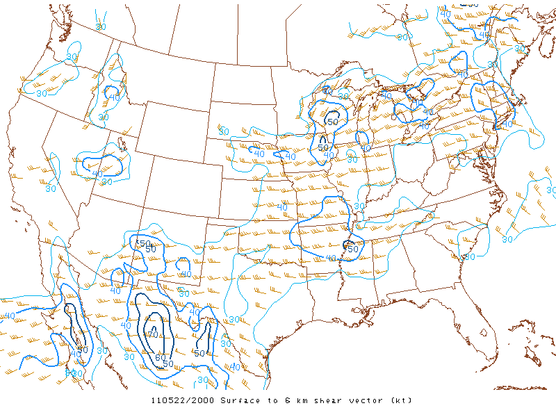
Last Wednesday, I woke up in Kansas City, MO hoping this chase day my 2011 bad luck would turn around. I got out the door pretty early heading east along U.S. 36 targeting Columbia, MO where it appeared discrete tornadic supercells would form and be fairly long-tracked. The conditions present on this chase day were fairly similar to the previous day in Oklahoma just further east. This was another high risk day, but after having an annoying high risk chase the day before I chose to stay away from the high risk-area as much as possible. I chose an area along I-70 that quickly was destabilizing with conditions quite favorable for supercells and tornadoes with 2,500J/kg of CAPE, 0-6km shear at 50kts, a moist boundary-layer and backing winds at the surface, and low LCL's around 750m. I wanted to blast back west along I-70 to intercept a tornadic supercell near Sedalia, MO early on however, I made a good decision to turn around as I noticed a few "blips" along a remnant outflow boundary back east along I-70. These "blips" would later become supercells and produce a few brief tornadoes. Luckily, this day I was in perfect position and made the right decision by staying-put near my target. I sat south of Kingdom City, MO just south of I-70 watching many areas-of-interest as the supercell tried many times to produce a tornado with multiple funnel cloud attempts it finally dropped a cone tornado along a good ole' Missouri tree line. Damn Missouri trees! I did witness a brief touchdown along I-70 as I repositioned and caught a nice occluding rope tornado on the backside of the mesocyclone. After the occlusion the supercell tried once more to produce near Mexico, MO as it produced another cone funnel, but it quickly would dissipate as convection from the south cut off its moist inflow. Soon after I quickly traversed across Missouri into Illinois as it looked like some of the more favorable conditions were progressing into Illinois. I managed to cross the Mississippi River and get on I-72 where I found another supercell rotating near Winchester, IL that produced yet another funnel before becoming largely outflow dominate. At this point I called it a chase ending a 2-day chase trip on a successful note. Photos and some time-lapse video can be found below:
Distant clear as day cone tornado a few miles away along I-70 that did produce some damage...
First attempt...cone funnel! (center)
Cone funnel...(right) (luckily I had some time-lapse going at this time)
Rapid rotation (center) as this thing starts getting latched onto the boundary
Occluded circulation produces a rope tornado on the backside...
The mesocyclone begins to tighten up once more...
Almost produced yet again...
Wide-angle shot as it's about time to move north to try to keep up...
Winchester, IL supercell viewed from I-72 brief cone funnel (left)
Supercell becomes quickly outflow dominate with many cell interactions
One last shot along I-72 as I head home "happy" for once...
I've added a YouTube time-lapse (above)
That ends this successful chase day. Finally, I made the right decision and put myself in a good location to see a tornado. S-U-C-C-E-S-S! Storm reports can be found here as this chase day was yet another tornado outbreak. Now on to the next...
Mammatus outside Emporia, KS as I head home after some high risk blues...
Last Tuesday, I drove to Oklahoma with thoughts of wedges in my mind. I left Peoria, IL at midnight giving me plenty of time to get to my initial target south of Wichita, KS as this would be a high-risk day. During the day, I repositioned further and further south to tap instability ending up in Oklahoma near Enid, OK. This area and much of the high-risk area was prime for tornadic supercells characterized by over 3,000J/kg of CAPE, 0-6km shear at 50kts, and a very moist boundary-layer. It quickly became apparent that an approaching shortwave trough and dry line would easily provide enough lift to spark discrete supercells. Storms fired shortly after 3:00pm and I found myself racing southwest once again just a little too far behind for some odd reason. I managed to find the "first" supercell near Fairview, OK, but along the way internet-data problems really hurt my ability to chase effectively. I later found out once my internet came back online in this sparse area that I had just missed a tornado to my southwest maybe by 15 minutes...One of those cmon' man moments! This supercell was HP-ish and was very hard to observe any rotation...heck I didn't even snap a photo it was that ugly. I later retreat east hoping to catch a new supercell to its south which ended up being the "play" of the day outside Oklahoma City, OK as that supercell produced a long-lived rain-wrapped wedge along I-40. I eventually catch the tail-end of that supercell's life-cycle before reorganizing later to the east near Guthrie, OK, but once again rain-wrapped and hard to see off I-35. This was probably the most frustrating chase I've ever taken part in which made me think of retiring as a storm chaser...well only for a brief second or two. After getting past my disappointing attitude I made the decision to call it a chase and called it a night near Kansas City, MO where I ran into some picturesque mammatus near Emporia, KS. The photo actually kind of showed my sentiment of the chase day with mammatus with a blue-ish tint which echoed my "chase blues". Just two photos from a high risk...ya I know it was one of those kind of days...
Bout the only photo I could salvage on a horrific chase day for myself...
That's all for this post since this was one of those chases I'd like to forget, but here are the storm reports from the day illustrating a tornado outbreak did occur seen here. The next day would be an opportunity for redemption...
Supercell northeast of Iowa City, IA becoming outflow dominate...
On this chase day, I targeted eastern Iowa as it appeared this chase had some tornado potential in that area and eventually later in the day in Illinois as well along I-80. This area looked "ripe" initially for isolated tornadic supercells with 3,000J/kg of CAPE, 0-6km shear at 50kts, 0-3km SRH at 200m2/s2, a supercell composite of 12, and a moist boundary layer with dewpoints near 70°F. Unfortunately, what looked like a "great" start analysis-wise to a day promising supercells ended up not coming to fruition for the most part. Many factors contributed to a bust when it came to a potential tornado outbreak in the local-area. First, a pesky gravity wave from a left-over overnight MCS really screwed up the surface winds as winds veered at the surface to the southwest therefore "messing-up" the "nice" hodographs that were forecast the night before the chase. That's why nowcasting is just as important! Second, since the winds at the surface on up were pretty much unidirectional most of the severe thunderstorms that developed were multi-cellular in nature and had a tough time exhibiting rotation. One such storm however did show some rotation for most of the mid-afternoon around Iowa, City, IA. I chased this supercell, but once again missed a tornado as it did produced to my west...just seems like my luck up to this point this year. Anyhow, I ventured back home intercepting a few severe-warned storms in west-central Illinois on my way to Kewanee, IL. I added photos from this chase day below:
Supercell transitioning to outflow dominate northeast of Iowa, City, IA
More outflow dominate stormscapes as the shelf cloud moves toward my location
Unfortunately outflow dominate...ugh!
Portrait-shot...
I cross the Mississippi River and chase a few "hailers" back home on my way to Kewanee, IL with a nice anvil (pictured above)
This storm (above) was responsible for golf ball-size hail in Galva, IL as well as Cambridge, IL
Backside of the main updraft as it tosses some hailstones out of the sky off to my east
I arrive back in my hometown getting severe-warned twice within a two-hour period
Backside of a severe thunderstorm that provided some strange chaotic motion
Storm passes to my northeast as I get a view of the tilted updraft and a nice lowering under the storm's base (left)
Weak meso/funnel looking south toward Toulon, IL (nothing specactular, but you're left wondering what if)... I've added a YouTube time-lapse from my GoPro camera (above)
This was a tough chase day with lots of "promise", but came up short in eastern Iowa and west-central Illinois in terms of a tornado outbreak. Farther north in Wisconsin and even down south into Missouri they didn't manage so well however. Storm reports can be found here. Notice that most of the tornadoes formed in Missouri including the Joplin, MOtornado and in Wisconsin as those areas were not as affected by that gravity-induced gravity wave. Once again it leaves you wondering "what-if" in this area as we were very fortunate. Hey, we still have June here in Illinois remember...
A mini-supercell starts to lower its base along I-80 outside York, NE
About 3 weeks ago, I made a fast trip to central Nebraska to chase a cold-core setup that could prove to produce some tornado magic. Unfortunately, I was about a half-hour to a hour too far behind to catch the couple tornadoes that formed on this chase day. Frustrating, especially when you thought you left early enough. This area featured a low-CAPE environment with 2,000J/KG of CAPE, decent low-level helicity at 200m2/s2, and 0-6km shear around 30kts. I quickly drove west along I-80 and a few mini-supercellsformed in the destabilizing environment near the low-pressure center in central Nebraska around the city of York, NE. These storms did exhibit some rotation and "spin-ups", but were really lacking warm surface-based parcels, but nevertheless a couple of brief tornadoes formed thanks to decent low-level shear. I took a few photographs, but not many on this day as I would have hoped since the storms were really well..."grungy" looking. A few photos however can be found below:
A pretty cool shot here showing some upward vertical motion indeed... (Canon 70-300mm telephoto-zoom lens)
A distant severe thunderstorm along the NE/KS border to my immediate south...
Lots of spin...but no tornado here...argh!
Nice shot of a developing supercell and its (back-sheared anvil) A short YouTube video I've uploaded of some small hail along I-80 from my GoPro (above)
After a long drive and sunset approaching I headed back east on I-80 and ended this chase as quick as it started. The tornado reports from the day can be found here.
A severe thunderstorm briefly forms a wall cloud near Macomb, IL
A few weeks ago featured a short local chase near Macomb, IL. I documented a brief gustnado near Macomb, IL on this day as a severe thunderstorm pushed out some nice outflow along the recently tilled farm fields in west-central Illinois. This area featured a high-CAPE environment with about 3,000J/KG of CAPE, but wind shear was hard to come by with 0-6km shear barely even reaching 30kts even with the presence of a moist boundary-layer. Therefore, storms were mostly downdraft dominate. While everyone was heading for central Kansas I didn't have that luxury at that time, however the major tornado outbreak that was being forecast ended up busting anyway in the Great Plains. This was a kind of a boring chase day, but I was able to get everything set up and tested in my new chase vehicle for some "real" chasing in the following weeks... I've added a few photos below including one snapshot of the gustnado below:
My new chase vehicle's first chase... (2011 Ford Escape XLT)
Look closely (center) of a swirling gustnado I caught along U.S. 136...
Portrait shot of the wall cloud...
That's all for this chase day. Storm reports can be found here. Nothing spectacular, but some wind damage reports in my area due to the outflow dominance of these severe thunderstorms...