"The mothership has landed" as a supercell produces a tornado northwest of Kimball, NE
On
June 12th, I started the morning in
Sidney, NE after a terrible hotel experience the previous night. After spending the night in a cheap to say the least hotel where I slept with mosquitoes in my room all night I began to head west with an initial target of
Cheyenne, WY. I had been eye-balling this potential chase day for many days prior while I was traveling and photographing in Arizona and Utah. It seemed this day had "real" potential for not only storm chasing, but tornadoes as well. Kind of got that feeling if you didn't chase today you were really gonna regret it. By 11:00am, I was already at my target just east of
Cheyenne, WY at a gas station along I-80. The atmosphere was already primed as some low-clouds burned off and strong heating and moistening were occurring. All the models tended to point to several supercells in an arc from north of
Cheyenne, WY southeast into Colorado. My thoughts on the day were to let the northern storms that would fire early go and wait for the southern storms that would develop in Colorado move northeast into a very favorable area for tornadoes near I-80 by early evening. The area in which I sat along I-80 for a couple hours during the early afternoon featured
3,000J/kg of CAPE, 0-6km shear at
50kts, 0-3km SRH at
200m2/s2, a supercell composite of
12, the significant tornado parameter at
2, and a moistening boundary-layer with dew points near
64°F. By early-afternoon, storms
initiated off the Front Range near
Ft. Collins, CO and began moving northeast and quickly
became supercells. It appeared these supercells were maturing quickly so I began to head southeast on WY Rt. 214 toward
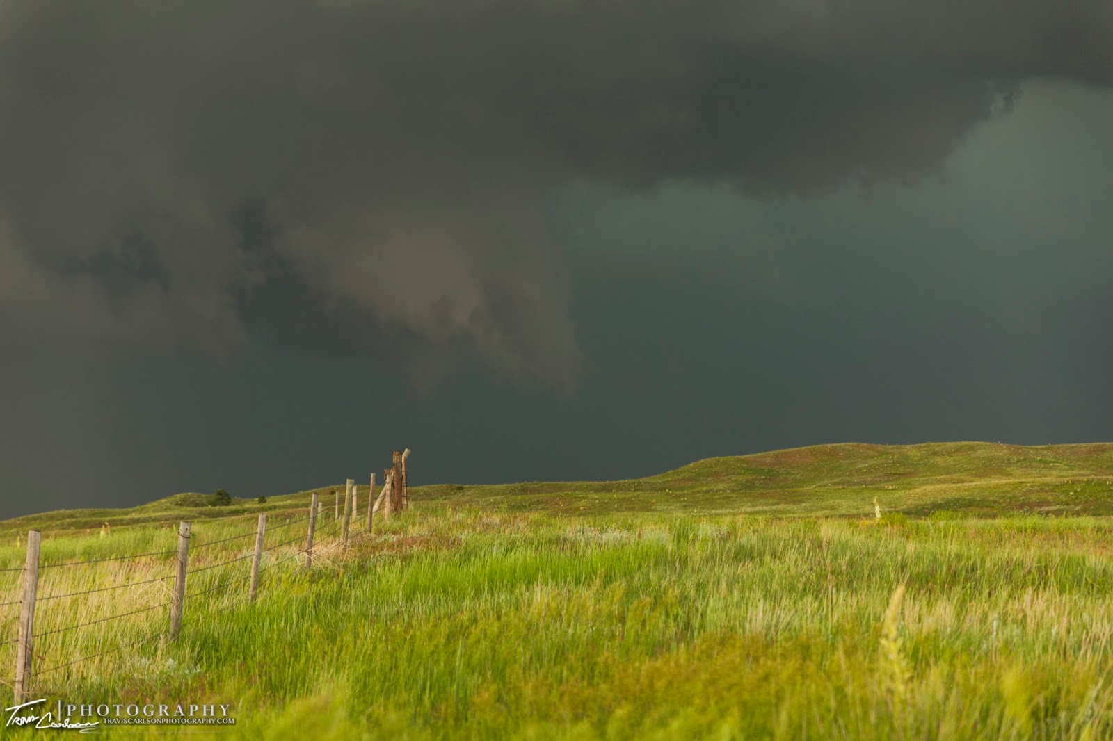
Grover, CO. I stopped and took a few photos of these maturing supercells off to my northwest. These supercells were really spinning at this point, but the road network was horrible. While I was heading southeast to get away from the precipitation cores of these two supercells my paved highway turned to gravel without much of any warning. My Garmin and GPS on my computer simply failed me on this go around. This "paved highway" turned to gravel for miles and miles that seemed like it was endless. It was one of the worst gravel roads I've ever come across where you'd be lucky to travel 20mph safely. Anyhow, these supercells I could tell were getting close to producing, but I was already out of position thanks to this terrible gravel road. I knew if I turned around I would still would have a big problem since I could only go so fast to catch back up to these storms and running across the precipitation cores of these storms. At this point, I thought my chase day that had such great potential was pretty much over as fast as it started. I quickly made a ball or strike call to head away from the supercells southeast continuing along this stupid gravel road to CO Rt. 14 which thank the good lord was paved. This however, took me way out of position farther away from the storms and go figure tornado reports started lighting up my computer. Frustrating would be an understatement! With that being said, I continued east and finally began to head back north on CO Rt. 71. This would take me back to the
supercell that seemed to go tornado crazy. I finally get a view of some "mothership" storm structure off I-80 where I stopped and took a few photos south of
Kimball, NE. I then preceded to travel north on NE Rt. 71 where I stopped and spent a good 20-minutes photographing some insane storm structure at this point. It seemed this
storm wasn't too far off from producing a tornado as I was only a few miles to its southeast. I began setting up my shot and snapping photos away and what do you know the supercell in the background decides it is gonna drop a nice cone tornado. How bout that?! I find myself photographing a mothership supercell only to have a tornado sneak into my shots in the background. I was ecstatic at this point so I continued to track this supercell once the tornado lifted where I saw a few intermittent tornadoes along NE Rt. 71 the rest of the evening. The surface winds were screaming during the evening which I'm sure was vital to tornadogenesis as well as these storms tapping into the moist-axis in western Nebraska. By far, the chase day wasn't easy! Missing the
Carpenter, WY tornado stung a little especially when I drove through that exact area prior, but I didn't end up empty-handed thankfully after the gravel road fiasco. I shot all these photos with my Canon 5D Mark III and the Tamron 24-70mm f/2.8 lens I rented for the trip which I will say was quite impressive. A radar loop from the NWS illustrating the tornadic supercells can be found
here. Storm reports from the
Storm
Prediction
Center (SPC) can be found
here. A great write-up of the tornado outbreak from the
National
Weather
Service (NWS) can be found
here as well. I've added a bunch of photos from the successful chase day below:
Welcome to Wyoming...and I love the brand new sign design!
First view of the southernmost supercell before it produces the Carpenter, WY tornado a half hour later...
Grungy mothership coming into view along I-80...
Mothership supercell while another supercell spins as well in the background!
A wide-angle view as it's starting to get good...
I traveled north of Kimball, NE and found a good spot off NE Rt. 71 to setup for about 20-minutes!
One of the better supercells I've been lucky enough to photograph in years!
Surface winds were very strong at this point and it wasn't too long after that tornadogenesis occurred from the supercell in the background...
This sucker kept putting out some intense CG's but I kept missing the really good ones, but I managed a lucky daylight bolt in this shot though...
Still spinning like crazy...
A tad wider on this shot!
This was my first time testing out a Tamron 24-70mm f/2.8 for storm photography and it's safe to say I'll be purchasing one fairly soon as it greatly exceeded my expectations...
Funnel attempt in the background...
I was hoping this mothership would tornado as I had it framed on my camera really well at my location for a good while...
This supercell sure delivered on storm structure!
"Omnious skies"
"Tornadogenesis"
A nice cone tornado develops a few miles to my west-northwest!
Quite unique to have a mothership in the foreground and a tornado from another supercell in the background!
"The chase"
Tornado #1
Getting close to the rope out stage...
Closer-view...
Tornado beginning to rope out!
Tornado #2
Intermittent touchdowns in the background...
Mothership getting mean...
I begin to drive north to catch back up...
"The spinning bowl"
Tornado #3
Wide-angle shot of this quick tornado!
Tornado #4?
It seemed in that dark mass something was going on, but about a mile too far away to tell for sure...
Another supercell comes into view!
This one was getting more messy, but man it sure did try on many occasions...
"Rotating mass"
Tightening rotation!
Almost there...
I thought it might drop a quick one here as it got oh so close and funneled...
Couldn't quite do it...
This was one of the most interesting chase days for myself that I can remember. My forecasting didn't miss a beat during the morning and I sure targeted the right area. If it wasn't for an unpredictable gravel road my execution would have been nearly perfect on this chase day. How often can you say that? If you chase enough you know that almost never happens. Something usually goes wrong. You usually make a forecasting error, navigation error, target the wrong storm, chase the storm at the wrong time, have no luck, etc. There are so many variables that have to go your way to say the least. Mother Nature sure did deliver on this day though! I also chased on June 14th and I'll add pictures from that chase in an upcoming post.