On August 16th, I once again had the day-off from work and monitored the weather situation throughout the morning. It appeared the main severe weather risk would be in downstate Illinois, but I knew here in central Illinois we ought to get an "early show" sometime during the morning hours as the cold front marched through Iowa into west-central Illinois. I set my alarm rather early to wake up and take a look at the radar. I was up before 7:00am as I was already seeing convection passing to my north through northern Illinois. With that being said new convection was forming however along an outflow boundary to my immediate west toward the Mississippi River. By 7:30am, I was already heading out the door with the equipment to grab a few shots of the approaching convection. I headed west on U.S. 150 and would set up on the north-side of Peoria, IL immediately behind my place of employment which gave me a decent view of the northwest horizon. By 8:00am, this convection was morphing into a nice Mesoscale Convective System (MCS). I could make out a nice shelf cloud in the distance approaching my location so I sat here and shot some time-lapse video and a few photos as the shelf cloud passed overhead before the frequent lightning forced me to call it a morning. I've added a few photos and some video before I headed indoors to escape the lightning barrage and heavy downpours that accompanied these storms below:
First view of the shelf cloud looking north...
Closer-view of the approaching shelf cloud!
One of the favorites I shot on this morning...
This MCS was organizing rather quickly at this point!
Another cool shot...
The last shot from the morning as I chicken out not wanting to become a lightning fatality statistic...
I've added a YouTube time-lapse (above)
That wraps up this brief post. I'll update accordingly with more severe weather or photography posts over the next few weeks...
On August 9th, I had the day-off from work so I monitored the weather situation throughout most of the morning. After analyzing the setup and keeping tabs on model-runs over the last few days I thought that central Illinois still posed a severe weather risk despite low probabilities by the Storm Prediction Center (SPC). It did look as though the best severe potential existed in Indiana during the evening, but storm initiation would occur earlier in the day in north-central Illinois. This was where enhanced lift under the left-exit region of unseasonably strong jet stream would begin to punch into an unstable air mass. By noon, I had the gear packed up and began heading north out of Peoria, IL as the sun broke through some pesky low-level clouds. The atmosphere quickly began to become unstable with surface heating and a moist boundary-layer in place. I targeted an area less than a hour from home-base along the I-74/I-80 interchange where it looked as though convergence was increasing around 1:00pm. This target-area was characterized by nearly 1,500J/kg of CAPE, 0-6km shear increasing to 40kts, and a moist boundary-layer with dew points pooling near 70°F. I quickly found myself "laying back" though not wanting to show my hand too early. I spent a hour continuing to analyze near Camp Grove, IL at a local wind farm (rest-area). While here I began to see upward vertical motion increasing in the (Cu) field as well as the first "blips" on radar showing up to my northwest near Galva, IL. I let this "shower" intensify for a little bit than dropped down the hammer and headed west on IL Rt. 17 that would put me on track to intercept this intensifying thunderstorm. From here, I dropped south of Wyoming, IL after snapping a few photos as intensification continued. I would quickly get a great view just north of Duncan, IL of a developing supercell that had some mid-level rotation at times. At this point, it featured a nice wall cloud that was hugging the rural-Stark County landscape. I shot some photos and time-lapse video enjoying the view. I knew I had to keep up with this supercell as it continued to intensify so I preceded to head south and back east along familiar country roads north of Princeville, IL. This storm was rather photogenic initially when it got its "act together". As this supercell approached Dunlap, IL it began to encounter convection to its south which would mess up its inflow. By this point, it was mostly outflow dominate as it headed into Peoria, IL. I still kept up hoping for it to organize again farther southeast so I hopped on I-474 and blasted east to get out ahead of it. I stopped at Goodfield, IL to take another look, but I wasn't too impressed with the "blob" of convection it had now morphed into so I set my eyes on new severe-warned convection that was looking impressive to my north near Varna, IL. I headed northeast to catch this supercell along U.S. 24. By mid-afternoon, I caught up this supercell along I-55 just south of Pontiac, IL. I stopped at a rest-area along the interstate where I took some more photos and video of this supercell as well. This one slammed me pretty hard though with dime-size hail and wind gusts near 60mph. I couldn't avoid a "what the hail" moment on this chase day unfortunately. I got lucky with no damage to speak of though! After riding out that supercell another formed back to the northwest so I stopped for a good hour outside Flanagan, IL to shoot some more video and snap some more photos. This one was rather outflow dominate though, but featured a nice shelf cloud. At this point, the most severe convection was shifting into Indiana so I headed back west arriving back into Peoria, IL by 7:00pm. It was a rewarding chase and being that this day fell on another day-off was a plus. I've added photos and some time-lapse video from the chase below:
First view of the developing rotating updraft in the distance...
Watched her blossom into a supercell right on cue!
Rapidly intensifying with a nice
well-defined wall cloud (right)...
Wide-angle shot of this developing supercell!
More blossoming convection!
A nice wall cloud here...
Another portrait-shot as this supercell approaches...
One more photo of the departing convection of this
unseasonably strong August storm system... I've added a YouTube time-lapse (above) I've added a GoPro video (above) I've added Part II of my GoPro video (above)
Overall, I can't be at all disappointed in this chase day especially for August. Hopefully, we get some more chances before fall kicks-in soon. Stay tuned for more updates/posts...
Over the last couple of weeks I've shot a few photos of the on-going severe drought in the local-area around Peoria, IL that may go down as a historic drought for the U.S. The current drought monitor for the U.S. can be found here. Closer to home, portions of the Midwest are also in a severe drought as well seen here. For the year, Peoria, IL has around a 9" inch deficit in terms of rainfall. This drought started during the spring and has worsened over the summer in this area. Last winter was quite dry in this area as well. Many have asked why haven't we had much in terms of severe weather here in Peoria, IL. Well quite frankly you might as well blame the drought. With much of the U.S. in a severe drought our severe weather season has been quite tame compared to years past. The reason can be explained by analyzing the jet stream. It got pushed north into Canada far earlier in the summer than is typical. This has allowed a stubborn ridge of high pressure in the Great Plains to become nearly stationary creating a nice heat dome earlier in the year. This heat dome has been quite persistent keeping the storm track well to the north where we only get periodic chances for severe weather in the "ring-of-fire" as weak cold fronts drop down in a northwest-flow regime from Canada. Since the heat has been very persistent we have also lost a lot of soil moisture as well which just heats up the ground faster leading to more 100°F heat. All of these factors contribute to the lack of severe weather. Tornadoes over the last few months have been well below-normal across the U.S. as well. It doesn't surprise me and it shouldn't surprise you either because that's to be expected with the above mentioned factors. It's why Canada is on pace to set a record for tornadoes this summer! Anyhow, I don't foresee any "drought busting" storm system's in the near future. We will have to wait for the late-fall and winter to try to make up this deficit. The good news, I think we will! I'm usually not an optimist by any means, but I believe this winter will be really "interesting" here in central Illinois. I caution you though as long-term forecasting is about as accurate as throwing a dart. That's the damn truth! However, after a tame winter last year I think this winter will make up for it in terms of precipitation, but trend more toward normal for temperatures. We'll just have to wait to see how that prediction pans out. The scope of this drought has really surprised me and was quite unexpected this summer. I've added photos below of the severe drought conditions present in the local-area below:
Signs of a severe drought seen here in this
Illinois farm field!
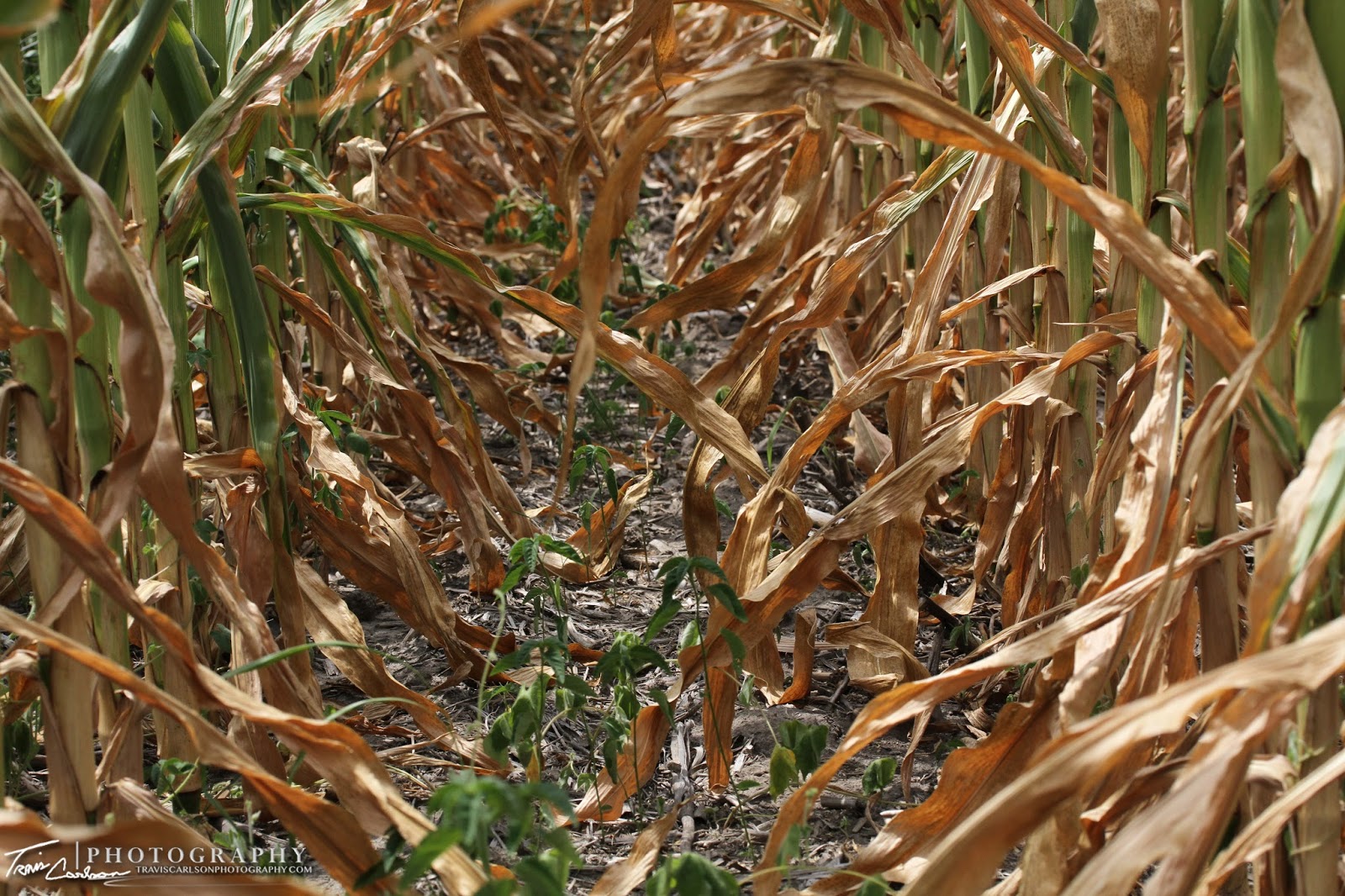
The corn crop this year is pretty pathetic
across the breadbasket of the U.S.
The sun setting at this wind farm on another 90°F day...
A tough year for farmers to say the least...
A great photo of the ground cracking seen here (above)
a typical sign of drought conditions...
A scorching summer sunset in rural-Stark County, IL...
The drought is so bad that this farmer gave up
and mowed down some of his corn crop!
The drought of 2012 is sure to go down
as one for the record books...
One last photo as the corn crop is basking
in the intense summer heat!
That's all for now. I'll update as time permits. Hopefully, we will get some much needed rain soon as we start to inch closer and closer to fall. Hard to believe summer is nearly over already as the days are already getting shorter in terms of daylight. Stay tuned for future posts.
This summer, I have been able to capture many beautiful displays from good ole' Mother Nature over the last few months. Even with the persistent drought in-place Mother Nature has sure provided some beautiful photos for myself. Many of the photos below are from earlier this summer before the severe drought conditions had kicked-in. I visited a local nursery (Hoerr Nursery) in Peoria, IL to capture many of the photos below. I also photographed a local wind farm as well. With the on-going drought it has been a tough year to get severe weather or a drop of rain for that matter. Therefore, I've concentrated on many other aspects of photography to make the time pass so to speak this summer. I had a tough act to follow after last year's collection. Anyhow, many of my favorite photos I have shot this summer I have posted below:
One of summer's beautiful displays! (macro-lens)
I'm a big fan of pink...FYI ladies...
When I took this shot I new it would be "one" of
my favorites pretty quick!
Another beautiful shot!
One of my favorite locations as of late at a local wind
These were gone pretty quick thanks to the drought!
A scorching summer sunset on August 2nd...
Crop-duster in-action!
One last close-up... (Canon 70-300mm telephoto-zoom lens)
Struggling cumulus trying to break
through the head dome!
More beautiful summer blooms!
Getting setup for an evening of photography...
Bubbles!
These guys were hungry...
More of Mother Nature's stunning colors!
The sun starting to set on the drought-stricken landscape...
More crazy colors!
Another good shot!
Summer sunset at a local wind farm...
A bee! (macro-lens)
Roses are red...
Doesn't that make you want to take a dip?!
Hard to imagine these were "cooked" months
ago because of the drought...
One of the few rainy days provided this photo-op!
Another awesome shot!
The wind farm yet again...
Another cool shot!
Talk about a fiery flower!
More good stuff...
A nice portrait-shot!
Wind farm with a lake-breeze boundary in the distance...
Lady in red?!
More of Mother Nature's magic...
Some hot pink here!
A nice observing angle helped this photo! (macro-lens)
A rose, yet again...
The heat is on...
A tree randomly in the middle of this wind farm...
A brief shower provided a nice photo-op here...
Quite an array of colors present!
Sprinkles don't help much during a drought...
One last photo of summer's best!
That ends this large post. It has been a good summer for photography which has kept me quite busy during the drought here in central Illinois. I'll update if any interesting weather hits the local area and I find some more time for photography over the next month. Until then...


.JPG)
.JPG)


.JPG)


.JPG)
.JPG)


.JPG)


.JPG)


.JPG)


