Wednesday, June 27, 2012

06/16/12 Peoria, IL Supercell & MCS

Some brief rotation evident in the clouds north of Peoria, IL as
a supercell merges with a Mesoscale Convective System (MCS)...

On June 16, I was back in Peoria, IL and working till 7:00pm, but I kept close tabs on the weather situation. I had good gut feeling when I arrived at work that morning that we would be in for quite a storm later that evening across central Illinois with quite an unstable air-mass in place. A cold front was also pushing in from the west and the models were hinting at a decent MCS rolling through central Illinois later that evening due to a Mesoscale Convective Vortex (MCV). By 7:00pm, when I got off work I drove to my apartment picked up my camera(s) and camcorder and headed out as convection was already developing to the southwest and a fairly nice MCS was less than a hour away. I setup shop just northwest of Peoria, IL to grab a few photos of the shelf cloud as the MCS began to move into the local-area. This area was characterized by 2,000J/kg of CAPE, 0-6km shear approaching 30kts, and a very moist boundary-layer with dew points at 70°F. By this time, some convection developed out ahead of the MCS to my southwest and had some super-cellular characteristics as it began to move overhead before the MCS would overtake me. There was also a tornado-warned storm with a notch in the MCS just to my north as well at this time. The storm to my southwest though really provided the better photo-opportunities as the shelf cloud was largely unorganized at least in this area. This storm that had developed near Pekin, IL had some nice brief rotation from my vantage-point as it had some "splitting supercell characteristics" probably due to the fact it was attempting to form a "comma head" feature along the northern flank of the MCS. Pekin, IL actually sounded their sirens for this same feature due to the rotation that could be seen. As it moved overhead I had a great view of lots of spin above my location and at times was pretty rapid due to the fast storm motion. It was pretty cool to watch! Anyhow, I eventually got swallowed up by this storm and got pelted with dime-sized hail along U.S. 150 before taking shelter in my garage at my apartment. Torrential rain and vivid lightning at this point kept me in my garage for nearly a half hour. Once I felt conditions were safe I headed back inside calling it a evening as darkness fell. I've added a few photos and some time-lapse video of the shelf cloud below:

Shelf cloud just west of Peoria, IL...
Updraft of the storm that formed over Pekin, IL with
a hang-me-down below the base (center)!
Another wide-angle shot of the shelf cloud...
A portrait-shot of the base to my south!
MCS approaching (right) as this storm (left)
is about to merge...
Looking south at the impending convection!
Here comes some rain and hail soon enough...
Circulation a couple of miles to my southeast!
Some spin evident overhead trying to become organized here...
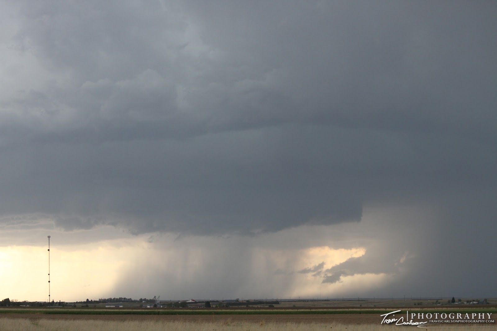
The best photo from the bunch showing the circulation and the
approaching rain/hail shaft (right) to my southeast!
Things calm down a bit leaving behind an eerie looking sky...
 
I've added a YouTube time-lapse (above)

I can't complain on this "chase day" as I worked nearly all of it and was still able to catch severe convection right on cue as I got off work in Peoria, IL. That almost never happens! That's all for now. Stay tuned for more updates over the next couple of months of local storm chases and photography as well. Until then...

Tuesday, June 26, 2012

06/07/12 Western Nebraska Supercell

Western Nebraska severe convection along I-80 west of
Sidney, NE along the WY/NE border...

On June 07, I woke up in Sidney, NE after rooming at a Holiday Inn. Yes, I did stay at a Holiday Inn Express last night in this case! It appeared on this chase day that storms would fire along the Colorado Front Range and just east of the Laramie Mountains in Wyoming. While most headed southwest into Colorado once again I hung out in Sidney, NE most of the day as I was contemplating playing the northern target and not get suckered into Colorado. This time I made the right call, but storms fired even farther north than I originally anticipated along I-25 in Wyoming northwest of Wheatland, WY. I began to head west during the mid-afternoon so I could intercept some developing severe thunderstorms. This area along the NE/WY border was characterized by 2,000J/kg of CAPE, 0-6km shear at 40kts, a supercell composite at (8), and a moistening boundary-layer with dew points near 60°F. A tornado-warned supercell was already ongoing heading into Wheatland, WY with confirmed tornadoes, but I was already a tad too far behind to catch up to this tornadic supercell. So I decided to hope something would develop farther to the southeast and be in a decent position if storms indeed fired. That they did as convection began to build in western Nebraska along I-80 around 5:00pm. These storms had some supercell characteristics and I shot some video along with some photos as well south of Kimball, NE along NE Rt. 71. Overall, though they turned into a rather big "blob" of convection. After being slightly annoyed by the chase day overall and with darkness approaching I decided to start heading east along I-80 to eventually call it a night at a Best Western in Kearney, NE. I got some much needed sleep in hopes of getting out the door early the next day to begin heading back to Illinois to wrap up my two-week vacation. I've added photos and some time-lapse video from this chase day below:

A supercell's rotating updraft west of Albin, WY...
 Nice mid-level rotation on this developing supercell!
Spin, baby, spin!
 You usually made the right forecast if you see this pass by...
 More convection developing...
 An interesting updraft trying to mature...
 I shot this outside of Kimball, NE just to the east of the airport!
 More convection along I-80 in western Nebraska...
 This storm would actually later become a split!
 One last shot to end on as I continue to head east on I-80...
 
I've added a YouTube time-lapse (above)
 
I've added a brief GoPro video (above)

That just about wraps up this post. I ended up making it to Kearney, NE around 10:00pm on this evening and roomed at a Best Western knowing I'd have quite a long drive back to Illinois the next morning as I would close-out my two-week vacation a tad early due to the lack of severe weather in the forecast. Plus, I wasn't planning on chasing in Canada anytime soon during the weekend. Overall, it was a fun two-weeks that left me with several great photos and I was able to visit destinations I have always wanted to see along my storm chasing travels. 2012 has been a tough season for tornadoes. This may be the first year that Mother Nature will leave me empty-handed when it comes to tornadoes after seeing the most in one year I have ever seen last year (4). Oh well, I've seen some great storms though and that's why you storm chase for the thrill, the experience, and to observe Mother Nature's beauty. I'll still chase locally this summer when I can of course. Stay tuned for future posts.

Monday, June 25, 2012

06/06/12 Colorado & Wyoming Supercells

A developing severe thunderstorm northwest of Snyder, CO...

On June 06, I woke up early after rooming in Wall, SD and began a long drive to Colorado as it appeared this area would see a couple days of severe thunderstorms including supercells just east of the Colorado Front Range. I headed west along I-90 and then began to drop south just south of Rapid City, SD and paralleled the Black Hills Forest along SD Rt. 79. From here I kept driving south on U.S. 385 passing through Alliance, NE and Bridgeport, NE reaching Sidney, NE by noon. After analyzing the situation it seemed a nice surface low was forming over Denver, CO therefore I'd have to head farther southwest to get under the cyclone and near the Denver Convergence Vorticity Zone (DCVZ) where landspout tornadoes have a "habit" of forming. I ended up with a target near Fort Morgan, CO as it appeared this is where convective initiation would begin around mid-afternoon. This area was characterized by nearly 2,000J/kg of CAPE, 0-6km shear at 30kts, and dew points near 50°F. Convective initiation began shortly after 3:00pm to my northwest around Keota, CO. I began to head north on CO Rt. 71 to intercept this developing severe thunderstorm to get a good-view as it matured. I stopped outside Stoneham, CO to snap several photos and shoot some video as massive chaser convergence began to occur. This storm really looked rather pathetic though at this point and seeing many storms developing in this area where one storm couldn't become dominate wasn't getting me too excited. In other words, I had a choice to make head south for later development in the evening or head north back into Nebraska to intercept a nice supercell east of Cheyenne, WY that was looking rather impressive on radar. I made the call to ditch the storms in Colorado and blast north to catch an ongoing supercell instead. I caught up to this supercell as I pushed west on I-80 along the WY/NE border outside the town of Pine Bluffs, WY. This supercell had some nice mid-level rotation for a time and even featured a nice hang-me-down funnel for a brief time as well. I took some time-lapse video while snapping several photos on the outskirts of Pine Bluffs, WY. Once when it appeared storms from the southwest were going to cut off my view I shot back east on I-80 and called it a chase at sunset. I roomed at a Holiday Inn in Sidney, NE knowing I'd be chasing once again the following day in this area. I've added photos and some time-lapse video below:

Some early morning convection outside Wall, SD
creates a brief rainbow along I-90...
A beautiful shot of the Colorado landscape as
convective initiation has begun northwest of Snyder, CO...
Another sign added to the collection!
Hay bales along the landscape with convection developing...
Portrait-shot of the updraft!
Another angle as this storm matures...
Chase vehicle (foreground) with convection
approaching (background)...
Along CO Rt. 14 outside Stoneham, CO before the
massive chase convergence...
Base a few miles away, but fairly unorganized...
View from the north as it was time to ditch this storm!
And another sign...
Initial view of the supercell northwest of Pine Bluffs, WY!
Closer-view with a nice wet RFD
(Rear Flank Downdraft) present...
Wide-angle shot of the supercell trying to get
some low-level rotation!

Just not enough low-level rotation...argh!
One last wide-angle shot as I begin to lose my view due
to convection moving in from the southwest...
 
I've added a YouTube time-lapse (above)

That's all for right now. After this chase, I had one more chase day left in the central Great Plains before I headed back to Illinois early since their was no formidable severe weather in the near future unfortunately. I'll update with that post soon...

Sunday, June 24, 2012

06/05/12 Badlands of South Dakota & Mount Rushmore

A scenic route (SD Rt. 240) that passes through the

On June 05, I decided to visit the Badlands of South Dakota and Mount Rushmore with no formidable severe weather risk across the Great Plains in the offing. I woke up quite early after rooming the previous night at a Best Western in Wall, SD and began heading south out of town on SD Rt. 240 that passes through the Badlands. I figured I'd do one photography session during the morning and one later in the afternoon as I arrived back to Wall, SD after visiting Mount Rushmore located southwest of Rapid City, SD. I spent about a hour and a half shooting many photos of the absolutely beautiful landscape. There is no doubt I'll be back here sooner rather than later. This was my first time visiting this location and I surely was impressed. I could spend endless days doing photography of the Badlands. Anyhow, after photographing the eroding rock formations I visited Mount Rushmore around noon and than later returned back to the Badlands around mid-afternoon to photograph them with a higher sun-angle. I've added many photos from this day's activities below:

A beautiful early morning shot of the Badlands!
 A shot of the sign which
is a frequent tourist photo-op...
 Bubbling cumulus over the Badlands by mid-afternoon!
 Mount Rushmore around midday...
(Canon 70-300mm telephoto-zoom lens)
I can't forget the South Dakota sign right?
One more I can add to the collection...
 What a beautiful landscape and a great view!
 Wildlife shot!
(Canon 70-300mm telephoto-zoom lens)
 A viewing point (left) of the Badland's buttes looking
down into the deep canyons...
 A portrait-shot of Mount Rushmore!
 Another great view!
A falcon in-flight?!
 Ongoing erosion can be seen here...
 A close-up...
Kind of was funny watching the tourists
with their "wimpy" cameras while I pull
out my beast of a DSLR camera!
 Talk about a scenic route...
 Crazy formations!
 Bighorn sheep relaxing on the crest of this hill...
 A wide-angle shot of the beautiful landscape!
(Canon 10-22mm wide-angle lens)
 A white-tail deer roaming the prairie
during the morning...
 A wide-angle shot of Mount Rushmore!
 Definitely not a "bridge-to-nowhere"...
 Portrait-shot of the bridge!
 Another beautiful view...
 Some falcons catching some thermals...
 A close-up shot!
(Canon 70-300mm telephoto-zoom lens)
 Another wide-angle shot here...
 One more close-up...
(Canon 70-300mm telephoto-zoom lens)
 A hot warm day nearly popped some convection
while I was in the park during the afternoon...
 Another wide angle shot...
 Cirrus clouds drifting over the Badlands...
 Portrait-shot of the amazing formations!
 Mount Rushmore yet again...
 Same photo, but with that Old School feel...
 One last shot before I head back for the evening...
 Convection indeed does develop as I arrive back to Wall, SD!
(This was shot from the balcony at my hotel)
 
I've added a GoPro video (above)

I would later call it a day after a long day of photography as I was already booked for the night at a Best Western in Wall, SD. I got a good night's sleep as I had another long drive the next morning to chase in Colorado. That post still to come...