Thursday, was a travel day to South Bend, IN. After a much needed nights sleep Friday we made a stop to the famous University of Notre Dame campus in South Bend, IN. It's one of the most prestigious colleges in all the land. Other than dodging some lake-effect snow that accumulated to 1-3" inches and withstanding some arctic chill during the visit the trip went pretty smoothly. Actually, this trip was my first taste of lake-effect snow as well. Of course, being at a venue as prestigious as this one I brought along my Canon T1i DSLR to photograph the campus landmarks. I must say I was impressed with their campus and the individuals that are given the opportunity to attend this university are sure blessed. On a interesting side note, campus visitor parking was cheaper at this prestigious university than my Alma materNorthern Illinois University. What's up with that now?! Anyhow, the last visit to the state of Indiana for myself was back in 2007 during a fall tornado outbreak so it has been awhile since I have revisited Indiana. I've included some photos of the campus below:
We're in Irish country no doubt...
Basilica of the Sacred Heart
Bet this campus is pretty well lit-up come nightfall
As far as the weather goes...looks like a light snowfall early this week followed by another system toward next weekend. That system next weekend could bring some accumulating snow as well, but way too early to make any projections on snowfall amounts in this area, but something to keep a watchful eye on in the coming days...
Ice storm causing many travel and power problems in Kewanee, IL (Wed-Thurs.)
Last Wednesday, a classic ice storm took shape across Iowa and portions of west-central Illinois. Some areas in Iowa received near a half inch of ice accumulation especially near Des Moines, IA. Closer to home in west-central Illinois many areas received a quarter inch of ice accumulation with areas around Kewanee, IL receiving between .15-.25" of an inch of ice accumulation. As you can imagine this created many problems around the area causing terrible driving conditions and widespread power outages. During this freezing rain event we were lucky enough to not lose power Wednesday even with a strong east wind snapping many tree limbs. Thursday, was a different story however. After lots of "flickering" the previous night we finally lost power in my area. Nearly a 7-hour outage here with areas to the west being without power for nearly 24hrs. especially in Mercer County, IL. So why did we get this ice storm this past week?...well we couldn't get rid of the melting snow pack due to persistent fog the previous weekend...this helped to create a shallow cold-layer near the surface. A high pressure center with it's clockwise rotation also helped to keep temperatures at or just below freezing as well thanks to the easterly component of the wind during the event. Think of the top-down approach if you have a meteorology background...falling snowflakes from the clouds above hit a warm-layer near 850mb which allows the snowflakes to melt forming raindrops. As these raindrops fall to the surface they encounter a shallow cold-layer...the raindrop cools below 32°F and freezes on contact to any surface below 32°F creating an accumulation of ice. Power lines, trees, and outdoor surfaces usually brunt the heavy load of the ice accumulation. This added weight due to ice accumulation on power lines and tree branches can and often snap tree limbs which fall onto power lines leading to power outages. The more ice accumulation and/or high wind speeds...the higher likelihood of a power outage during an ice storm. Anyhow, I documented this ice storm in the local-area and since I haven't done some "town photography" and I have really used up many photo-ops in the backyard this winter...I ventured all around Kewanee, IL Friday to get some "town/city ice storm shots". I was hoping to get some night shots as well Friday night, but sure enough in less than 6 hours it all melted...doh! I've added some hand-picked photos however below:
Textbook example of how you should measure ice accumulation
Street signs provide great photo-ops after an ice storm...
Alright, I finally took the lights down, but before I did I snapped this photo after the ice storm
Snow plow trying to keep up, salting many highways
Heavy ice accumulation here... (particularly trees oriented north-south)
I actually shot this on our rural-roadmaybe a mile or two away
East-facing garage...it's obvious why garage doors don'topen in these events routinely
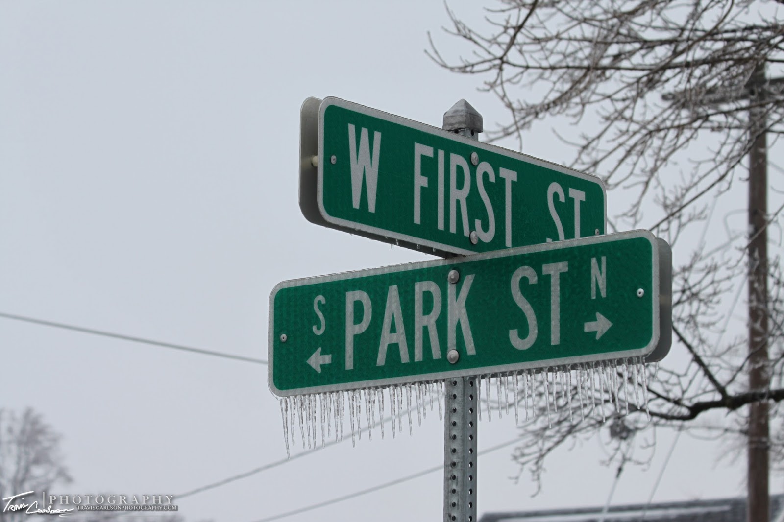
What's incredible is how uniform the ice can get on these street signs
Wind vane coated in ice as well...
Most roads were in decent shape...however try driving down some rural-roads after these events... (You'll be probably cursing up a storm)
Power line encased in ice...hence why many lose power folks...
Even the lawn is somewhat picturesque as well and not to mention a tad crunchy too
Macro-lens shot...this lens works wondersin the winter season
Home sweet home...only about 41% of Ameren customers in thiscounty were without power Thursday...
Probably my favorite rural-area shot from this ice storm
Power lines still coated with ice here in this small valley
Along Rt. 78 looking south (this highway actually was a joke until this past fall when the stimulus money arrived)
Farm in the background with ice coated Willow trees in the foreground
Black Hawk East College
This begins another section of ice storm photos from Kewanee, IL within city limits. Like I said I am still kicking myself for not getting some night photography photos..argh!
From pure observation it appears Kewanee, IL had more ice accumulation than I expected (.25")
Simple Walmart carts showing the after effects of the ice storm
Stoplights glazed over...
Street sign and an ice coated tree
New hospital on the southwest-side of Kewanee, IL
Ok, not the "going green" a storm chaser is thinking of...
What do you know...power crews are on the scene
Close-up...looks like their were some serious problems here...
Main St. for some reason I'm thinking of the "disconnect between Wall St. and Main St." or maybe that's just my political nature talking...hmm
This shot would have been 10x better with some sunshine
I thought this shot was interesting with an ice coated tree taking up the (foreground) with a street name sign in the (background)
Another stop light with the icy glaze... (again would have been spectacular at night) grr...
Willard St. outside Wethersfield High School
where I graduated what feels like forever ago (2004)
You can find these photo-ops everywhere you seemed to look...
Beach St. seems like a dumb name for a street in the Midwest
One more street name sign for the day
I've added a short YouTube clip illustrating the thaw this past Friday (above)
Well that's all for now...besides the cold here in the Midwest the weather should be pretty dull over the next few days except if you're located in the Southern Plains and Deep South. That's where another ice storm could be found along with some severe thunderstorms as well. I'll be making a short stop to South Bend, IN in the coming days...so I'll probably update at some point with some photos when I get back...
Winter beauty on our notorious tree-line for spectacular photos outside Kewanee, IL
Freezing fog developed across much of eastern Iowa and west-central Illinois Saturday night reducing visibilities in many areas and creating some slippery travel on roadways. This freezing fog also created some dramatic winter scenes as well come Sunday morning. For those unfamiliar with freezing fog...it occurs when the air near the surface has dew points just below freezing. This can cause a deposit of interlocking ice crystals as the sublimation process changes vapor directly into a solid phase in these rare events. If you have fog than theirs a possibility you have supercooled water droplets (water droplets below the freezing point) and if these stick to any surfaces you can get dramatic rime formations as well. Another similar type of frost is hoar frost, but this usually occurs on cold clear nights instead (radiation frost). The last instance when freezing fog occurred in Kewanee, IL was December 2007. In that case...the sun popped out and created a few dramatic shots with the deep blue morning skies. Actually, I remember this event like it was yesterday since it was the first time I used a DSLR camera. This past Saturday we lacked the sunshine however...but still some incredible winter scenes were found again which usually accompany these freezing fog events. Anyhow, I wandered around the backyard to find a few photo opportunities to illustrate this such event below:
I swear I've taken this same photo 3 or 4 times indifferent winter situations this winter i.e (Heavy snow, icing, hoar frost, and now freezing fog)...
Barbed wire fence with the interlocking ice crystals
Evergreen tree with the above mentioned
Amazing...even in January to find a "two seasons-in-one shot
Benefit of living in a rural-area... (fence posts and wire-fencing can create some awesome photo-ops)
As far as the weather over the next few days across my hometown...it looks like an icing event could be in store by midweek with models showing a classic freezing rain scenario...afterwards attention will turn to the upcoming weekend as I mentioned in a previous post. A powerhouse storm should develop in the western U.S. and will track across the central U.S. It appears currently we are looking at mostly a (significant) heavy rain event in this area which could cause some flooding issues...


