

Monday, featured a long 10-hour drive to western Nebraska to intercept and photograph some supercells along the dryline. There were many targets in play including the MDT risk area in South & North Dakota, but I decided to target North Platte, NE instead with a "dryline play". I figured you'd have a better chance to get more discrete storms in this area and the favored areas in the Dakota's had fairly poor road networks that would make chasing rather difficult. I began the long drive shortly after 2:00am Monday morning hauling west since it appeared there would be little to no "cap" in place most of the day in the target area. By noon, we already had a tornado watch in place across the area. My target would erupt supercells by mid-day northwest and northeast of the target and as they screamed north at 60mph they began to rotate with favorable shear. Good luck keeping up with those fast-movers! Unfortunately, road options killed my chances of chasing those supercells. By mid-afternoon, I'd seen nothing more than towering (CU) and I was hoping for something more to initiate while I waited for the dryline to bulge from the west. After not doing much of any chasing most of the day...finally by 5:00pm the dryline began to push and bulge east into my target-area of 3,000J/kg CAPE, 250-300m2/s2 SRH, and 50kts 0-6km shear aloft. However, the dryline lined-out quick and quickly unzipped the "cap". I was less than impressed, but once the dryline got into the area with strong destabilization occurring that all changed. Supercells quickly began to break off of the dryline (or at least try to). I watched the first storm approach on an overpass which was fun (50-60mph inflow gusts). This supercell quickly got its act together tracking northeast to the northwest of North Platte, NE. This storm did exhibit some rotation for a time as it was tornado-warned. That storm however was hauling a** at 60mph and knowing I wouldn't be able to keep up I ducked back south and east to pick up another developing supercell that would track through North Platte, NE. This storm would also become tornado-warned and produced many pronounced lowerings, a wall cloud, and a nice funnel as well. It was oh so close to producing many times...argh! I also observed some NSSL vehicles with Vortex2 at this time. I would later track the circulation on this supercell near Maxwell, NE. I got a taste of the RFD at this point and I knew it wasn't probably going to produced as I got a "cool" sample of its RFD (Rear Flank Downdraft). However, it was a nice view seeing the circulation rotate from the backside. I usually don't get a chance to view mesocyclones from this perspective all too often. Eventually that storm tracks away and dissipates as the dryline overtakes me. I quickly remembered some lectures from in the classroom in my college days at Northern Illinois University how you can feel that sharp contrast within a few miles when the dryline overtakes you. Wow, it sure is the case! It really was awesome to feel the change in the atmosphere over a few miles for once. Once the dryline pushed east of my location I drove back east on I-80 to punch through once again hoping I'd get some beautiful storm structure shots near sunset. As I do the dryline does indeed line-out however, but I did manage to be again in the right place as a notch begins to form with an embedded supercell along the dryline. I witness at this time a nice funnel cloud and could easily see this area-of-rotation within the shelf cloud that was trying to become tornadic. I continue east as the storms cycle many times along the dryline showing areas of embedded rotation. I found myself stopping at every exit I could grabbing some photos along the way. This was really a fun chase near sunset with beautiful storm structure and the dryline created some amazing photos-ops as well. I've added a ton of my favorite photos from the day below:
 Convective inhibition (CIN) weakening around mid-day
 Turkey tower (Canon telephoto-zoom lens)

Second supercell beginning to "mushroom cloud"

Convection beginning to initiate by mid-afternoon

Portrait-view...
 Orphan anvils and good ole' I-80
Convective debris and anvil (Canon telephoto-zoom lens)
 Chase vehicle and "atomic bomb" anvil
An overpass overlooking I-80 West
(50+mph inflow gusts at this point)
 Supercell becoming more and more organized
 Supercell with mid-level rotation...
 Vortex2 on the scene...
 Heck, even NSSL makes an appearance
 Supercell #2 quickly showing signs of promise...
Several efforts to produce would follow...
 Wow...what a tease!
 So close yet so far...
Obvious funnel and the closest "she" would get...
 Supercell #2 forms a new wall cloud here
 A testament of just how powerful this updraft became...
(Love this shot)
 Supercell now entering North Platte, NE at this point
 Wall cloud and circulation now a few miles to the northwest
 I now start heading north to keep up with the supercell
 I head north getting a taste of the small and rather "cool" RFD
 An amazing sight watching this circulation
rotate a few miles away
Shelf cloud to the southwest
 Tornado-warned supercell #3 with
an embedded mesocyclone (right)
 Looking southwest at an amazing whale's mouth
 Notch I was referring too where obvious rotation was
occurring that nearly produced on a few occasions
 Wide-angle view of that beautiful whale's mouth
 An even closer view of the shelf cloud overhead and
notch/area-of-rotation (left-center)
 Embedded supercell still showing signs of
promise along the dryline
Severe convection approaching Kearney, NE
 Shelf cloud continues east along I-80
Notch along the shelf cloud making an attempt to "produce"
 Best whale's mouth I've ever seen in my chasing travels
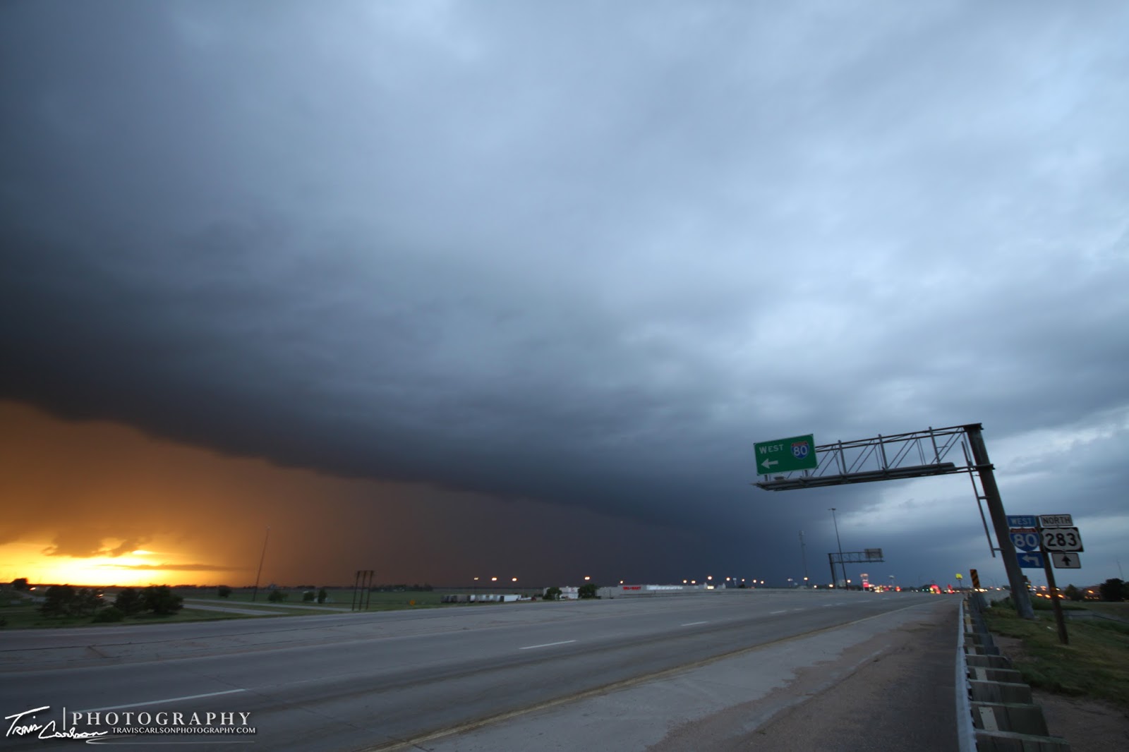
 Shelf cloud at sunset along I-80 in western Nebraska
 Beautiful sunset along the dryline on this evening
 Shelf cloud rollin' across this overpass...

Convective debris and anvil (Canon telephoto-zoom lens)

An overpass overlooking I-80 West

(50+mph inflow gusts at this point)
Several efforts to produce would follow...

Obvious funnel and the closest "she" would get...

(Love this shot)
rotate a few miles away
Shelf cloud to the southwest

an embedded mesocyclone (right)
occurring that nearly produced on a few occasions
notch/area-of-rotation (left-center)
promise along the dryline
Severe convection approaching Kearney, NE

Notch along the shelf cloud making an attempt to "produce"


The dryline and shelf cloud at sunset
Tuesday morning, I continued the long 10-hour drive home through Iowa as pulse-convection began to develop as early as 7:00am. I stopped a few times to use the early-morning sun-angle to shoot some of the developing towers along the cold front. Here are a couple below:


Another shot of the developing pulse convection in Iowa
Wednesday evening, featured more pulse convection (top-down) and I took some time to shoot some photos near sunset on this day as well. Here are some I shot looking east toward the Illinois River below:


Mammatus clouds developing under the anvil...

The cold front at sunset as instability begins to decrease

Orphan anvils as the sun begins to set in the west
Quite a long post, but early last week really did feature some beautiful convection I thought. We turn the page on May and head into June. As we do it appears an active zonal pattern will setup across the north-central Plains into the Midwest over the next few days with periodic MCS activity associated with a stalling cold front. That's exactly what I like to hear...