Monday, June 28, 2010

06/23/10 Squall line & Damage

Approaching shelf cloud near Woodhull, IL
entering an
extremely unstable environment

Last Wednesday, I ended up chasing after work as a strong cold front sagged south across west-central Illinois. The environment ahead of this cold front was rather ripe for severe weather. Extreme instability in place, plenty of shear, and a very moist boundary-layer with dewpoints near 80°F. I blasted north on IL Rt. 78 as I got off work targeting near the Geneseo, IL area. Storms began to initiate around 3:00pm which meant I was a little behind being an hour to the south. Anyhow, a tornado-warned storm organized near Muscatine, IA and headed east so I dropped south on I-74. I caught a view of a nice shelf cloud, but this once tornado-warned storm quickly went outflow dominate upon arrival. I continued south and than east to keep up with the developing squall line as it entered the very unstable environment to its south. Outside Galva, IL I noticed some rotation along the shelf with some meso-vorticies. At about this time, I got a phone call from home wondering "if that was just a tornado that went through?" At first I thought it was a joke, but quickly I understood the situation was definitely not a joke. It turned out this severe squall line produced 75mph straight-line winds at my residence which knocked out power, uprooted at least a couple trees, tore a roof off a storage shed, and completely obliterated another storage shed while at the same time taking down 70ft pine trees. This quickly ended my chase as I continued to drive back home on U.S. 34. Getting even home though proved quite difficult with one tree completely blown over/uprooted onto road 650E. I barely got through as this tree was blocking 3/4 of the road at this point. Once I finally got home I found lots of debris in the yard. After letting the storm pass off to the south and east toward Peoria, IL I proceeded to get a better idea of the damage. At first from family member accounts I thought this might have been a rain-wrapped tornado based off what they heard. Especially, when I noticed a hook signature on radar developing along the shelf cloud where our residence is located. This made me quite curious! After the storm passed I did my own damage survey around the area finding some inconsistencies with one of the 70ft pine trees stripped to its bark, uprooted trees, some trees only lost their top-half as well. With that being said however, I didn't find any "swirling" motion in any of the farm fields which is a tell tale sign of a tornado. It also appeared that even though there were some inconsistencies that didn't quite match up with straight-line wind damage most of the trees that did go down were oriented in the same direction. Overall, based on my assessment it looked like straight-line wind damage to me, but since I was chasing in another location I guess I'll never know. I've added some photos from the brief chase and damage photos from home below:

Shelf cloud traversing along the Illinois prairies
Gusty outflow moving overhead from a once tornado-warned storm
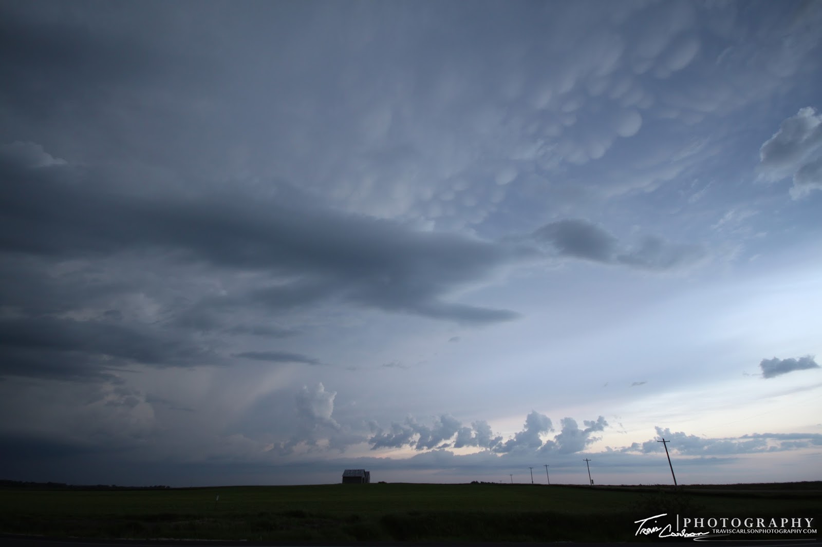
Mammatus clouds and sunset after the chaotic storm
One of my favorite local photo-op locations
will never look the same...
Pine tree snapped quite easily here...
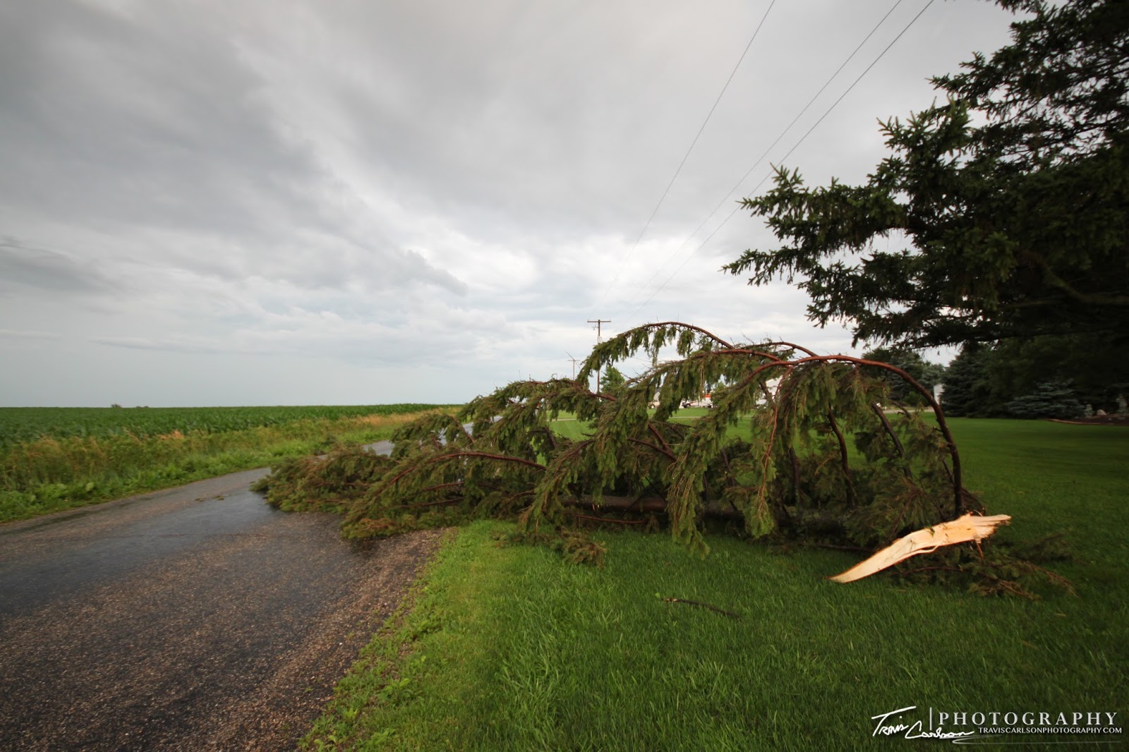
Several of those 70ft pine trees down...
(note their orientation though as it's quite
important for damage surveys)

This was interesting as this tree had half of it
plucked and was tossed as well...

Tree blocking half of road 650E
Another tree blown-over onto the road
Next day photo showing how this storage
shed was obliterated

Storm ripped the roof off this other storage shed
providing a not so welcome skylight
Another view of our pine trees that couldn't withstand
Mother Nature's wrath Wednesday
What a mess...
Lots of clean-up that will forever change the
northwest skyline at our residence


Out of all of the chases this spring...this one was the least amount of fun. You always want storms close to home to make chasing easier, but on this day it was way too close and we ended up as one of the several damage reports across the state. The weather pattern responsible for the severe weather over recent weeks has finally shut-down though and we'll get a much needed break this week after a very active June across the Midwest.

06/21/10 Wicked HP Supercell

Monster HP supercell northwest of Macomb, IL

Monday, featured a surprise local chase for myself. I had the day-off and was busy editing recent video and photos, but kept a close-eye on the local weather situation most of the day. This would later turn out to be quite important toward evening. A departing MCS allowed for rapid destabilization in its wake in SE Iowa and west-central Illinois...sound familiar at all? This area has been a hot spot this month folks! After some analyzing from home it was becoming more apparent this area was becoming rather ripe for supercells by mid-afternoon. 3,000J/kg of CAPE, Supercell composite approaching 20, and 0-6km shear around 50kts. After reviewing mesoanalysis most of the day and surface obs. and seeing agitated cumulus in SE Iowa I quickly got out the door headed westbound on U.S. 34. As soon as I get on the road a supercell quickly goes up in SE Iowa and goes tornado-warned sparked by an ejecting shortwave. At this point, I'm hauling west to get out in front of a massage HP supercell with it crawling towards the Mississippi River at 20mph. A few tornado reports come in along the river while I'm heading west trying to catch up. Eventually, I finally do and get a view of this beast west of Macomb, IL south of the town of Tennessee, IL with the sirens-blowin' alright! This storm meant business folks! The gust front and shelf became visible right away with a nice inflow tail getting sucked into the rotating updraft. I sat here for a good while taking many structure shots as it had some incredible structure at this point. I kept up with this HP supercell as it progressed southeast toward Macomb, IL all the way to its demise near the Illinois River. Along the way this supercell had some insane inflow that stretched nearly the entire northern horizon and looked like it could produce a damaging tornado with rapid and violent rotation. Other than a few funnel clouds and rapid rotation it never produced a stellar tornado at least that most of us (chasers) could observe however. Their may have been some brief touchdowns, but none that I saw for that matter. This beast seemed more outflow dominate than anything, but this sucker was sure rotating strongly all evening though. It was a hell of a storm to say the least! I've included some of the better structure photos I was able to grab along the way below:

Wide-angle shot almost lookin' panoramic here as this
supercell was just massive at this point

Inflow band (right) was just insane!
Wall cloud and brief funnels (center)
That'll get your attention...quite a beast!
Southwest flank (above)
This thing put out some great structure all evening
Area-of-interest (center) inflow band (right)
Funnel cloud/tornado attempt...
Farther east now near Industry, IL
Inflow has weakened a bit, but the supercell
still has rotation at this point
Wide-angle shot of a stellar rotating updraft
Almost witnessed my first gustnado here...
look at that clear as day cone (left)
 Trying to wrap up...
Wide-angle shot of the cone extending from the gust front
This storm had some crazy rotation at times...
Monster HP supercell with green-ish tint
with hail
suspended aloft no doubt
Wicked rotation at this moment
Supercell becomes outflow dominate
as it approaches the Illinois River

I didn't get a tornado from this chase, but I'll always take supercell structure whenever I can get it especially so close to home. Stay tuned for another post featuring yet another chase.

06/18/10 Shelf Cloud Madness

Shelf cloud from a MCS and whale's mouth
nearly overhead at this point outside Kewanee, IL

Friday, (June 18th) featured a MDT risk of severe weather in the local-area for an enhanced damaging wind threat. I had to work on this day so I didn't end up with the stellar shelf clouds most chasers ended up with in northern Illinois. Nevertheless I ended up taking a couple photos as I headed off to work around 2:30pm. This MCS that formed in eastern Nebraska raced east across Iowa and crossed the Mississippi River around 1:30pm hitting my hometown (Kewanee, IL) around 2:00pm. My Davis outdoor weather station recorded the surging outflow as the shelf cloud made its appearance in the western horizon with a peak wind gust between 45-55mph. No major damage here in the local-area from this derecho (widespread damaging wind event). I was later treated with yet another derecho that I drove into after 9:00pm as I headed home after work. I've included a few photos of the shelf cloud and whale's mouth below from the daylight derecho:

First view of the shelf, but not as
picturesque as I was hoping for...
Looking north as it's a tad disorganized at this point at least
Chaotic motion with a picturesque
whale's mouth looking north
Whale's mouth along Rt. 91 in rural-Stark County, IL
One more shot of the whale's mouth as I head off to work

That's all for this chase log. Also, if you'll interested in more info about this event click here. That link will take you to a write up from the NWS-Romeoville office. I'll be posting some photos from a few more chases here in the coming days as well. Stay tuned.

Friday, June 25, 2010

06/17/10 Northwest Iowa Supercells

Squall line with embedded supercells
near Pocahontas, IA


Thursday, (June 17th) was an indeed frustrating day. The night before the event I targeted the Spencer-Sheldon-Storm Lake, IA triangle. As I made my way to northwest Iowa on this chase day everything seemed to be coming together for some nasty severe weather including a possible strong tornado, but Mother Nature left me in the dust it would turn out. The target-area featured 4,000J/kg of CAPE, plenty of shear, a very moist boundary layer with dew points around 70°F, and a sharp cold front serving as the lifting mechanism. The cap held most of the day as the atmosphere quickly destabilized after morning convection. Unfortunately, storms developed farther northeast than even I expected and therefore veered the surface winds over the target-area. In other words, that killed the directional shear needed to sustain rotating updrafts over the target-area as initiation began near my location. I do recall the 4.0km WRF (God model) however showed a similar trend in its 12z run that day and apparently I should have paid more attention to it perhaps. Turned out the main show with tornadic supercells developed initially as crappy storms to my northeast that I didn't bother with which turned out to be the wrong decision on my part. Seeing tornado after tornado report come in to my northeast though was quite a sad feeling especially when one was a wedge...grr. Anyhow, after screwing that up I ended up chasing some storms near Storm Lake, IA along the cold front, but because of the veered surface winds these storms struggled to become supercellular. Another problem that contributed to the lack of tornadoes was how each storm would "seed" another to its southwest flank which would cut off the updraft once when it would begin to lower its base. Ya, not a great day for myself chase-wise. I made the best of it though chasing a squall line with embedded supercells along the drive home along the Highway 20 corridor in north-central Iowa. I was treated with some spectacular mammatus clouds at sunset though...which made driving home tornado-less a tad more easier. I've included photos from the chase day below:

Convective initiation underway west of Storm Lake, IA
An attempt to form a wall cloud
Supercells producing tornado after tornado to the northeast
while I get their anvil shadow...argh!
Anvil shadow-effect killing vertical growth here
not
allowing the atmosphere to "bake"
Finally, a wall cloud but well too late in the evening
Wall cloud to my northwest near Albert City, IA
Wall cloud bout to get undercut...frustrating!
Wide-angle shot of convection struggling
to
maintain supercell characteristics
Squall line with embedded supercells near Pocahontas, IA
Embedded supercell (lowered base (right))
Lots of mammatus clouds on this chase evening
Squall line that would show some areas of brief rotation
at times, but nothing spectacular

A mammatus and anvil-filled chase
East of Pocahontas, IA at this point
Stunning mammatus at sunset here
Squall line continues east as the sun begins to set
Close-up of the amazing mammatus clouds on this evening
My mobile weather station providing a nice photo-op
More and more mammatus shots

It was a tough chase, but they all can't go smoothly. I'll update with another post as soon as I get some free time as Mother Nature has kept me way too busy as of late...