

becoming outflow dominate...
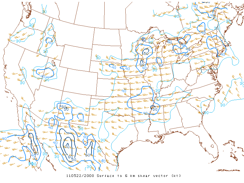
On this chase day, I targeted eastern Iowa as it appeared this chase had some tornado potential in that area and eventually later in the day in Illinois as well along I-80. This area looked "ripe" initially for isolated tornadic supercells with 3,000J/kg of CAPE, 0-6km shear at 50kts, 0-3km SRH at 200m2/s2, a supercell composite of 12, and a moist boundary layer with dewpoints near 70°F. Unfortunately, what looked like a "great" start analysis-wise to a day promising supercells ended up not coming to fruition for the most part. Many factors contributed to a bust when it came to a potential tornado outbreak in the local-area. First, a pesky gravity wave from a left-over overnight MCS really screwed up the surface winds as winds veered at the surface to the southwest therefore "messing-up" the "nice" hodographs that were forecast the night before the chase. That's why nowcasting is just as important! Second, since the winds at the surface on up were pretty much unidirectional most of the severe thunderstorms that developed were multi-cellular in nature and had a tough time exhibiting rotation. One such storm however did show some rotation for most of the mid-afternoon around Iowa, City, IA. I chased this supercell, but once again missed a tornado as it did produced to my west...just seems like my luck up to this point this year. Anyhow, I ventured back home intercepting a few severe-warned storms in west-central Illinois on my way to Kewanee, IL. I added photos from this chase day below:

northeast of Iowa, City, IA

More outflow dominate stormscapes as the
shelf cloud moves toward my location
 Unfortunately outflow dominate...ugh!
 Portrait-shot...
 I cross the Mississippi River and chase a few
"hailers" back home on my way to Kewanee, IL
with a nice anvil (pictured above)
 This storm (above) was responsible for golf ball-size hail
in Galva, IL as well as Cambridge, IL
Backside of the main updraft as it tosses
some hailstones out of the sky off to my east
 I arrive back in my hometown getting
severe-warned twice within a two-hour period
Backside of a severe thunderstorm that provided
some strange chaotic motion
 Storm passes to my northeast as I get a view
of the tilted updraft and a nice lowering
under the storm's base (left)
 Weak meso/funnel looking south toward Toulon, IL
(nothing specactular, but you're left wondering what if)...
I've added a YouTube time-lapse
from my GoPro camera (above)
shelf cloud moves toward my location
"hailers" back home on my way to Kewanee, IL
with a nice anvil (pictured above)
in Galva, IL as well as Cambridge, IL
Backside of the main updraft as it tosses

some hailstones out of the sky off to my east
severe-warned twice within a two-hour period
Backside of a severe thunderstorm that provided

some strange chaotic motion
of the tilted updraft and a nice lowering
under the storm's base (left)
(nothing specactular, but you're left wondering what if)...
I've added a YouTube time-lapse
from my GoPro camera (above)
This was a tough chase day with lots of "promise", but came up short in eastern Iowa and west-central Illinois in terms of a tornado outbreak. Farther north in Wisconsin and even down south into Missouri they didn't manage so well however. Storm reports can be found here. Notice that most of the tornadoes formed in Missouri including the Joplin, MO tornado and in Wisconsin as those areas were not as affected by that gravity-induced gravity wave. Once again it leaves you wondering "what-if" in this area as we were very fortunate. Hey, we still have June here in Illinois remember...