Saturday, June 23, 2012

05/30/12 Southwest Kansas Supercells

A tornado-warned Mesoscale Convective System (MCS)
creates this amazing photo outside Dodge City, KS...

On May 30th, I began driving to southwest Kansas around dawn to chase an enhanced-severe weather risk that was being forecast. It looked for several days that this day would provide a good chance to catch some supercells that would later morph into a possible derecho across the southern Great Plains. By early-afternoon, I had already crossed into Kansas along U.S. 183 after several hours of driving west on I-80 through Iowa and Nebraska punching through some elevated convection along the way. This convection was actually already severe-warned with hail being reported along I-80. I set up shop most of the day south of Rush Center, KS along U.S. 183 awaiting convective initiation along a differential heating boundary as an approaching shortwave would eventually erode the cap. This area was characterized by nearly 3,000J/kg of CAPE, 0-6km shear at 50kts, a supercell composite approaching (12) to the southwest, and the presence of a moistening boundary-layer with dew points near 60°F. Winds were also locally backing along this boundary leading me to believe this was a decent spot to wait for storms to initiate in a few hours. Around 1:30pm some convection tried to develop as the cap was already slowly weakening however this convection was elevated along the boundary at this time as I had just arrived to my target. I sat here most of the afternoon until storms began to initiate after 3:00pm just to my northwest. I watched (LP) supercells initiate in this area off to my northwest for about a hour. I shot many photos here and some time-lapse video as well southeast of Ness City, KS along KS Rt. 156. These supercells were initially (LP) low-precipitation, but quickly began to morph into severe-warned (HP) high-precipitation blobs throughout the evening which later formed a substantial Mesoscale Convective System (MCS). This MCS that was tornado-warned blasted me on U.S. 50 with 65mph winds, dime-sized hail, and torrential rain east of Dodge City, KS. I was able to get a few pics and brief time-lapse of some great structure this MCS featured before it knocked me around a bit along the highway. I actually took shelter at a gas station to get the vehicle some protection from any hail damage. Once the MCS passed I headed west to Dodge City, KS as I could see the sun already starting to peak back out under the anvil on the back-side of the severe convection. This was a very rewarding decision! I was presented with one of the best sunsets I've ever seen with on-going convection off the my south. The mammatus overhead was absolutely breath-taking with lightning (crawlers) mixed in. While I was here shooting photos, I witnessed one of the strangest things in years of chasing I've ever seen. This MCS had some insane chaotic motion going on as the convection began to move away. I watched lots of spin in the clouds to what seemed to morph into a white condensation funnel. It sure was spinning which caught me off guard at the time being in a location of the storm where you wouldn't expect to see something like this, but it definitely was not a tornado. Who really cares though? This thing created a spectacular photo to my south with a rainbow in the background and for me is just as good. The turbulent and strange motion going on behind here was a head scratcher to say the least for myself! For me it was amazing to watch and it bugs me to this day I didn't have my video camera in my hand. Oh well, I sure made out like a bandit with the photo(s) though! After snapping nearly an endless amount of photos I called it a chase and picked up a hotel room at a Best Western in Dodge City, KS and called it a night. I've added several photos and some time-lapse video from this chase day below:

Supercells begin to initiate to my northwest
along the Kansas landscape near Ness City, KS!
 Initial elevated convection along the differential
heating boundary...
Spectacular shot here with convection initiating in
the background as my chase vehicle awaits
to chase the approaching convection...
An orphan anvil off to my west-southwest!
 The chase is on...
 A nice (LP) supercell initiating to my northwest!
 I have a damn good view at this point...
 Wide-angle shot of the rotating updraft
of this supercell!
 This supercell becoming more HP-ish along U.S. 183
(looking north)...
 Supercell and a typical Kansas wheat landscape!
 Beautiful wide-angle shot as the Kansas wheat give you
great insight of the inflow into this supercell...
 Portrait-shot of the stormy
skies at this point overhead...
 Supercell yet again, but this time I'm farther north on
U.S. 183 south of Rush Center, KS as the supercell
transitions to outflow dominant...
 Stormy skies loom in the background behind 
this abandoned Kansas oil well...
Wide-angle view of the developing MCS along
U.S. 50 east of Dodge City, KS!
Another view with some nice mammatus here as well
(looking north)...
 Some very nice structure here as I'm moments
away from getting 65mph straight-line winds!
 Oh boy, here comes a core-punch (not by choice)!
 I punch through and find this
double rainbow just east of Dodge City, KS...
 Mammatus present here as the sun begins
to create some dramatic scenes...
 Chase vehicle, mammatus, and rainbow all in one shot!
 Close-up shot of the rainbow amidst the rain to my south...
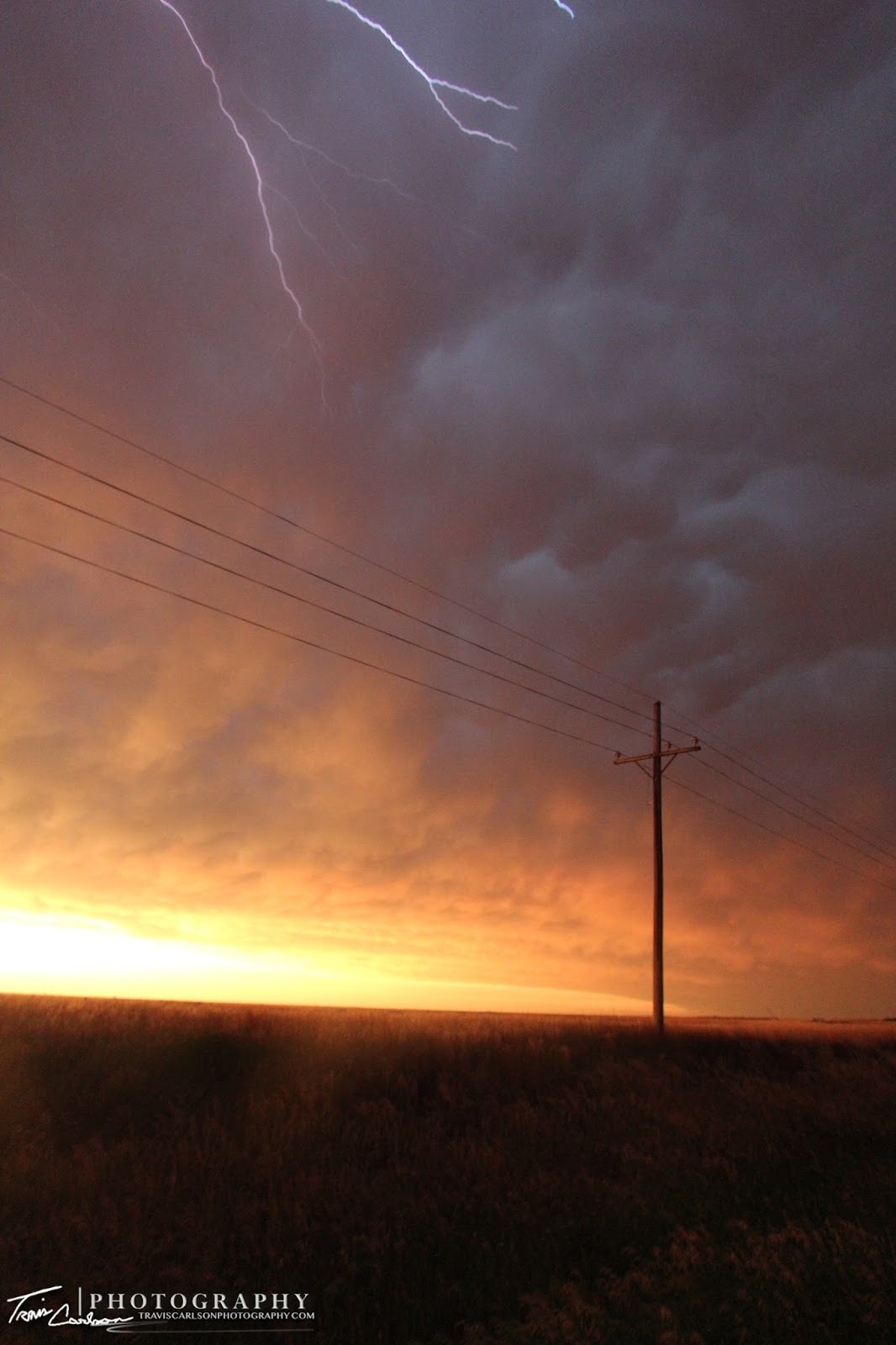
 A crawler sneaks into this portrait-shot!
 Another great shot!
Lots of "spin" forms what "appears" as a
white condensation funnel a few feet off the ground here
with a distant rainbow in the background what
a crazy shot! (before-shot)
Lots of "spin" and rapid motion present!
This is what I was referring to that was
absolutely insane to watch... (after-shot)
(Looks like horizontal tubes present as well (right))!
 The song paradise was playing on the radio at this time!
"Lying underneath those stormy skies, this could be paradise"
I couldn't have said that better myself...
 First time I've been able to photograph blue-lightning...
Some crawlers can clearly be seen sneaking
into this sunset shot!
 One more of the rainbow with the chase
vehicle in the foreground...
Wow, what a sunset!
(Canon 70-300mm telephoto-zoom lens)
Beautiful shot here as well!
A beautiful golden sunset which marks the
end of an active severe weather day
 across southwest Kansas...
 One more shot of some anvil crawlers along U.S. 50!
 
I've added a YouTube time-lapse (above)
 
I've added a short YouTube time-lapse of the MCS (above)
 
I've added a GoPro video (above)

Overall, this was quite a rewarding chase! Kansas sure didn't disappoint me on this day with some great photogenic supercells and a beautiful sunset! I got some much needed rest later that night and actually drove back to Illinois for a few days as their was a lull in the severe weather threat over the next day or two before I headed back out to the Great Plains for the rest of my vacation. More to come...

Thursday, June 21, 2012

05/29/12 Niabi Zoo: Coal Valley, IL

A jaguar at Niabi Zoo in Coal Valley, IL...

On May 29th, instead of making a long trip to Oklahoma to chase some severe convection that was being forecast I decided to spend one more day in the local-area after chasing in west-central Illinois the previous evening. On this day, I decided to make a trip to Niabi Zoo in Coal Valley, IL to snap a few photos of some wildlife. I had been meaning to do this for quite some time, but I just didn't have the necessarily time to do so. Since I was on vacation and the weather cooperated I decided that this would be a perfect day to visit this zoo again. It had been quite awhile ago that I had visited this zoo as I do vaguely remember being a small child at that time. I must be getting old since I've only vague memories of that particular experience. I guess my youth is already starting to disappear eh?! Anyhow, this turned out being a relaxing day that sure felt nice especially knowing that I would be waking up quite early to make a long drive to Kansas the next day with an enhanced-severe weather risk in the offing. I've added a few of my favorite photos I shot from the day below:

These guy's are out relaxing and
enjoying the weather it sure seems like...
 Shot with my Canon 70-300mm telephoto-zoom lens!
 Our national bird: the Bald Eagle!
 A Mallard enjoying a nice swim...
 Giraffes hanging out inside getting some breakfast...
 Kangaroo about to go hopping around!
 One of the Ninja turtles?
 A close-up shot of a Llama!
 An Asian Elephant at the zoo...
 Close-up shot of a Mallard!
 A great shot here with the fountain in the background
as the mallard swims in the foreground...
 A zoo is not a zoo without a Zebra right?!
 A female lion enjoying some sun!
 A Black Swan searching for some food...
 A close-up of a Hawk here...
 I'm very familiar with goats since we have some
back home, but here is one at the zoo too!
 A great shot of two mallards hanging out together here...

That's all for now. After visiting the zoo, I headed back to my hometown to rest-up for a long drive in the early morning hours as I expected to chase in southwest Kansas on May 30th. It was a day that sure left me with many spectacular photos! That chase day and future posts to come...

Sunday, June 17, 2012

05/28/12 West-central Illinois Severe Convection

A severe thunderstorm explodes into the atmosphere
northwest of Davenport, IA along I-80...

On May 28th, I started my two-week vacation with a quick local storm chase across eastern Iowa and west-central Illinois near Davenport, IA. This chase day didn't hold much hope for some tornadic supercells, but I thought I'd easily be able to grab a few good shots of some severe thunderstorms around sunset with a rather buoyant atmosphere in place. I targeted an area along an approaching cold front that was moving east toward the Mississippi River by mid-afternoon. This area near the Quad-Cites was characterized by 2,000J/kg of CAPE, 0-6km shear nearing 40kts, and a rather moist boundary-layer with dew points near 65°F. This chase day would later provide some spectacular photo opportunities! Sure gets a photographer in a good mood you could say. By 4:00PM, I headed north out of my hometown of Kewanee, IL along IL Rt. 78 and began heading west on I-80 outside Annawan, IL as convective initiation was beginning along the cold front near Iowa City, IA. I arrived along the famous I-80 truckstop around 5:00PM and began to get a good view of the developing convection. I headed back east from here as the convection was already overtaking me at this point and found an exit along I-80 just northwest of Davenport, IA to take in the rather photogenic convection. At this point, it was severe-warned and with the Dominator not to far behind me along I-80 it seemed this was the right storm to chase at this point. This storm really got its act together as it approached the Mississippi River and Moline, IL with several wind damage reports in that area. I followed this storm as it had some fairly nice structure as I stopped to get a few structure shots off the interstate near Colona, IL. At this time, the severe thunderstorm had a monster updraft/anvil that began to push off to my northeast. It also had some super-cellular characteristics, but quickly became outflow dominate and pushed out an outflow boundary into a rather unstable atmosphere to the south. I decided to let this storm go at this point hoping to get something even more intense to fire back off to the southwest along this outflow boundary. More severe storms did end up developing, but behind the outflow boundary to my dismay. Anyhow, I began to head south along I-74 and stopped again to take a few photos and video outside Orion, IL. A developing thunderstorm was becoming more organized at this time. This storm had some interesting characteristics with a nice well-defined wall cloud for a time. I shot some photos and some time-lapse video at this point and shot some more photos along U.S. 34 near a local wind farm and later headed back to my hometown of Kewanee, IL. As I arrived back home another thunderstorm began to develop and I was kind of chased by this one actually. I had a great-view of this storm however as the sun was beginning to set creating a rather picturesque sky along the Illinois landscape. I ended up calling it a chase at sunset and rested up for what I knew was a busy couple of weeks of traveling. I've added photos and time-lapse video from this local chase below:

A beautiful sunset in the western horizon as a
storm rolls in east of Kewanee, IL...
 A stout updraft accelerating into the
atmosphere with great contrast here!
 A nice base along I-80 just northwest of Davenport, IA...
 Juicy CAPE (Convective Available Potential Energy)
 present as convective initiation begins!
 Severe thunderstorm approaching the Mississippi River...
Some interesting structure on this severe
thunderstorm outside Colona, IL...
Closer-view of the severe convection moving
into west-central Illinois!
Explosive convection at this point...
Severe-warned thunderstorm now crossing the
Mississippi River, but becoming outflow dominate...
Outflow boundary (above) showing
quite an unstable atmosphere in place
just west of Geneseo, IL...
Pretty cool shot with my chase vehicle and some
sun rays peaking through the developing convection!
Robust convection...
(Canon 70-300mm telephoto-zoom lens)
A rather picturesque storm near Orion, IL!
Another shot of the outflow boundary "hanging around"
to my southeast...

Yet another shot of the outflow boundary
that pushed out of these storms nearly overhead...
A rather photogenic view in the western horizon...
Close-up shot of the well-defined wall cloud!
A great shot of the outflow boundary with warm-air rising
along this newly formed boundary...
Another angle of the lowering-base here!
One more close-up as this storm was pulling in some
juicy-air at this point...
A nice downdraft here moving overhead as
I drop farther south along I-74...
This one may be getting canvassed...
Absolutely beautiful!
A new wind farm outside Galva, IL as convection looms...
More convection approaching from the southwest!
Another picturesque wide-angle shot!
Hard to choose which one of these are going to be on
my wall in my apartment soon...
Umm...yeah what a beautiful storm along
this Illinois landscape east of Kewanee, IL!
One more of the beautiful sunset!
The thunderstorms depart leaving behind
mammatus at dusk back home...
 
I've added a YouTube time-lapse (above)
 
I've added a GoPro video (above)

This ended up being quite a rewarding chase since it provided lots of good photos from another marginal chase setup. That's why it's always nice to chase any storm you can since you just don't know what you'll see through your view-finder and your camera's lens. I will be posting many posts over the next couple of weeks as I have lots of photos and video to go through from the past few weeks of chasing and traveling across the Great Plains. More to come! Stay tuned.