

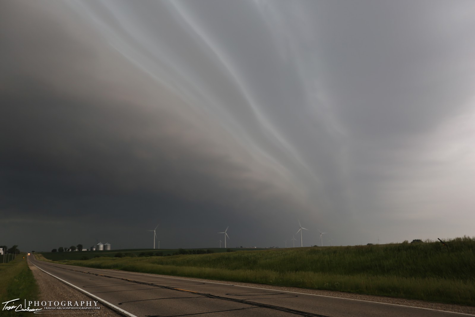
A photogenic shelf cloud overtakes a wind farm during the early morning hours near Camp Grove, IL
On June 7th, I ended up chasing most of the day in west-central Illinois as it was a busy day in the local area in regards to the weather. I woke up early on this day and took a peak at the radar on my iPhone and saw a non-severe Mesoscale Convective System (MCS) moving into west-central Illinois. I quickly rushed out the door and tossed the camera gear into the car. I ended up heading north on IL Rt. 91 and jumped on IL Rt. 40 to wait for the storms to move across a local wind farm outside Camp Grove, IL. Despite the lack of severe weather with this MCS it really was a treat to watch move overhead at this wind farm. This shelf cloud provided some "mothership-like" photos in the northwest horizon to say the least. I was quite pleased with this shelf cloud's structure that was rolling along the west-central Illinois horizon. I spent a good hour or so at this wind farm shooting photos with my Canon 5D Mark III and Canon EF 16-35mm f/2.8 II L lens. I ventured back to
Peoria, IL where I spent most of the day waiting for the atmosphere to
destabilize as some sunshine began to peak out of the clouds behind
the decaying MCS. I ended up targeting Brimfield, IL on this chase day seeing
some supercell potential west of Peoria, IL ahead of an advancing cold front.
By early afternoon, I began heading west on I-74 where I setup for the early
afternoon waiting for severe thunderstorms to initiate to my northwest. I found
a good spot along IL Rt. 78 near Brimfield, IL to watch towering cumulus
continue to build to the northwest. This area that I was targeting featured 3,000J/kg of CAPE, 0-6km shear
increasing to 35kts, a supercell composite of 8, and a very moist boundary-layer
with dew points near 72°F. By mid-afternoon, severe
thunderstorms began to initiate to my northwest. Storms
quickly began to erupt and move east toward my
location. I quickly moved east to keep up with a severe thunderstorm that was
becoming a supercell in my rear-view mirror especially near Brimfield, IL where
some decent rotation was observed. I continued east along I-74 heading back
northeast toward Peoria, IL on U.S. 150 as the rotation from this supercell
began to approach my apartment. At this point, I observed a well-defined
rotating wall cloud moving toward my location. This supercell was definitely a
high precipitation (HP) supercell. I shot several shots of the wall cloud and
a couple funnel attempts as I progressed east making it to my apartment as the rotation
was just gonna pass to my north. Despite rain falling, I quickly snapped some
photos of the mesocyclone in the northern horizon before I got munched from
severe storms to my southwest. Once I lost my view of the rotation I took refuge in my garage
for nearly a hour from torrential downpours and hail that was falling. Once
the storm moved away and I was unable to catch back up I ventured around the
area hoping for a good sunset, but pesky low-clouds behind the storms and training
thunderstorms put the kibosh on a photogenic sunset for myself.
I later would call it a day and headed indoors to get some much needed rest
after a full day chasing locally. I've added photos from the morning and
afternoon chase below:

My first view, at this point I already knew it was well worth getting out of bed and the short drive...

Getting closer...
 "It was windy" "That's intense!"

Wide-angle shot, looking southwest...

I leave, when the wind blows...

"Against the wind"

Quite a perspective to say the least!
 A view straight out of the movie "Independence Day" I'd say...
 "The mothership shelf"

Some insane structure!

Rd. 2 begins as severe thunderstorm initiation begins...

"Kaboom"

I thought this shot was worthy to convert to black & white...

Supercell beginning to gather more rotation visually to go along with a nice velocity couplet near Brimfield, IL

Rotating much stronger here...if we had just a tad more shear on a day like today we could of very well had a wedge wannabe here as the rotation was very well concentrated near the ground with low cloud-bases (LCL's)...

Looking due west at some funnel attempts!

Mother Nature teasing me at this point...Do I want to tornado or not?!

Farther east...pretty solid mesocyclone at this point north of my apartment passing about a mile to my north...

Suspicious feature to the northwest wrapped in rain...hmm!

A typical Illinois landscape to go along with the supercell!

A HP supercell tease! This supercell did cause some damage to my north and northeast with a 75mph wind gust reported...

I'm about to lose my view here due to rain and hail about to core me at my apartment, but I hung in there as long as I could...

I tried for a sunset to no avail, but I caught this developing thunderstorm near sunset though...
That's all for this particular chase day. I was quite pleased with the day as I captured an awesome shelf cloud in the morning and a supercell in the afternoon. If only every chase would go that way. I'll update once again in the coming days with more storm chasing posts.